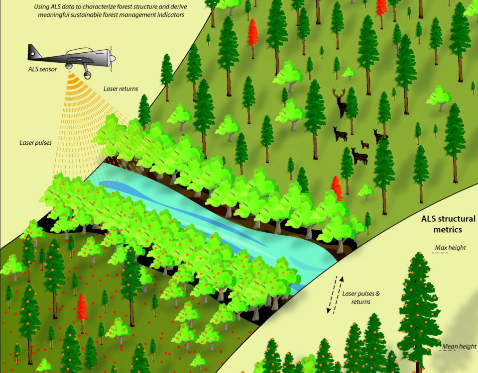
Forests are essential ecosystems that play a crucial role in maintaining the balance of our planet’s environment. They provide habitat for countless species, store carbon, and contribute to the well-being of human communities. As the world faces increasing environmental challenges, it becomes vital to adopt advanced technologies for forest management and conservation. One such innovation is laser scanning, which enables us to map and monitor forests from above with unprecedented precision and efficiency. In this blog, we will explore how laser scanning from drones or aircraft is revolutionizing forestry by facilitating forest inventory, ecosystem analysis, and wildfire risk assessment.
Understanding Laser Scanning
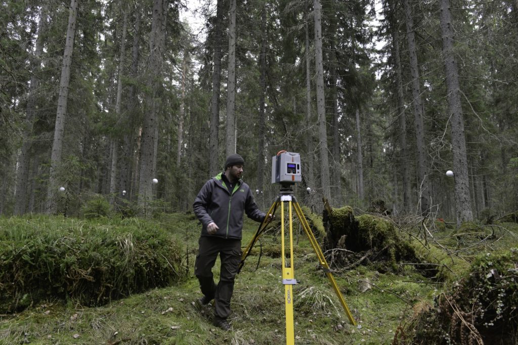
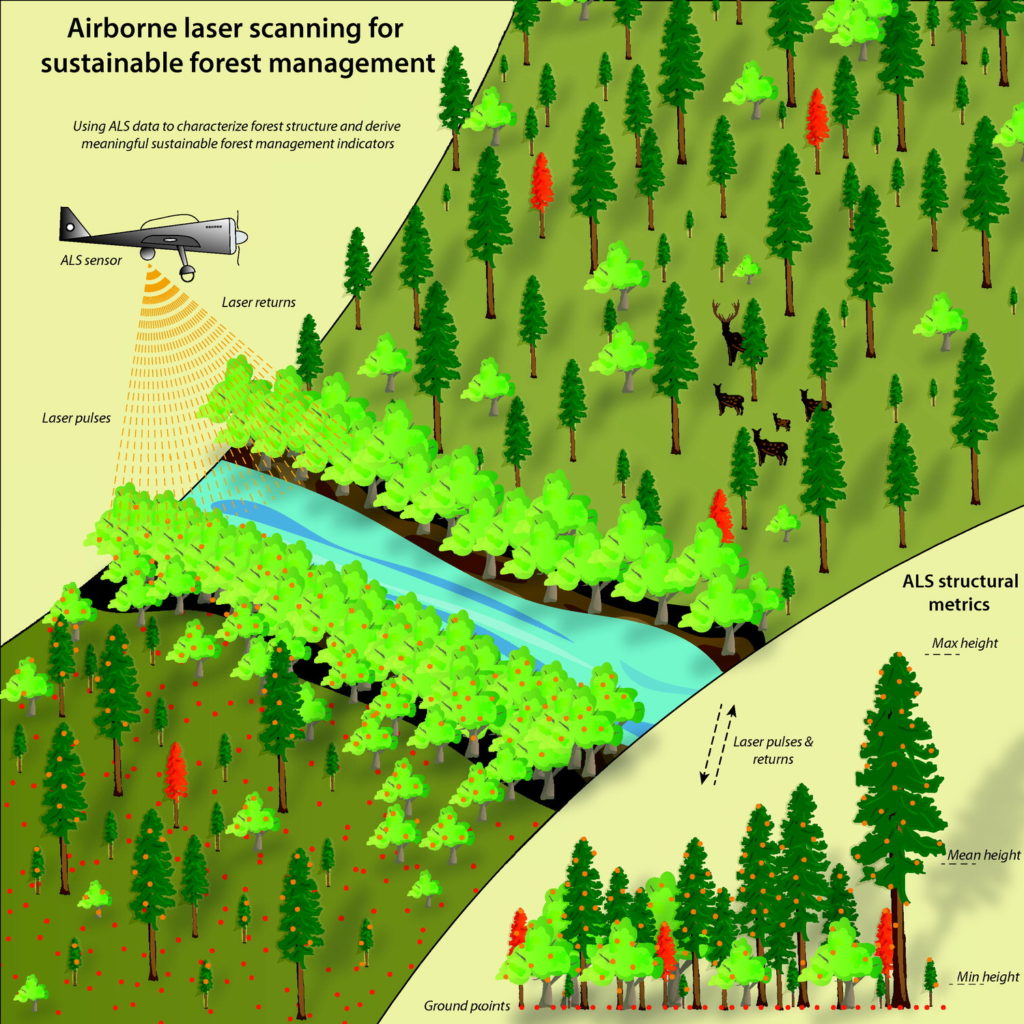
Laser scanning, also known as LiDAR (Light Detection and Ranging), is a remote sensing technology that utilizes laser beams to measure distances to objects or surfaces. In forestry applications, lasers are used to create detailed three-dimensional models of forested areas. These models provide valuable insights into the forest’s structure, composition, and health.
Laser Scanning for Forest Inventory
Traditionally, forest inventory involved field surveys and manual measurements, which were time-consuming and often imprecise. Laser scanning has revolutionized this process by allowing forestry professionals to collect vast amounts of data quickly and accurately. Here’s how it works:
- Data Collection: Laser scanners mounted on drones or aircraft emit laser pulses towards the ground. These pulses bounce off the trees and return to the scanner, measuring the distance between the scanner and the object.
- Point Cloud Creation: The collected distance measurements create a point cloud, which is a collection of data points in three-dimensional space. Each point represents a specific location in the forest.
- Data Analysis: Advanced software processes the point cloud data to create highly detailed forest maps. These maps include information about tree height, density, species composition, and more.
Benefits of Laser Scanning for Forest Inventory:
a. Efficiency: Laser scanning allows for rapid data collection over large forested areas, reducing the time and resources required for traditional field surveys.
b. Accuracy: The technology provides highly accurate measurements, reducing errors and improving the quality of forest inventory data.
c. Forest Management: Precise inventory data helps forest managers make informed decisions about harvesting, conservation, and reforestation.
Ecosystem Analysis with Laser Scanning
Laser scanning goes beyond simple inventory by offering valuable insights into forest ecosystems:
- Canopy Structure: Laser scanning reveals the intricate structure of forest canopies, which is critical for understanding light penetration, species distribution, and habitat quality.
- Wildlife Habitat Assessment: By analyzing the data, researchers can identify suitable habitats for various wildlife species, aiding in conservation efforts.
- Carbon Storage Estimation: Laser scanning helps estimate carbon storage in forests, contributing to climate change mitigation efforts.
- Disease Detection: Changes in the forest canopy’s structure can indicate the presence of diseases or pest infestations, allowing for timely intervention.
Wildfire Risk Assessment
In regions prone to wildfires, laser scanning plays a crucial role in assessing and mitigating wildfire risks:
- Fuel Load Mapping: Laser scanning helps identify areas with high fuel loads, such as dense vegetation or dead trees, which are more susceptible to wildfires.
- Fire Behavior Modeling: The data collected can be used to model fire behavior and predict its spread. Aiding in evacuation planning and firefighting strategies.
- Post-Fire Assessment: After a wildfire, laser scanning can be used to assess the extent of damage. And plan for forest regeneration and recovery.
Conclusion
Laser scanning technology is transforming forestry by providing accurate, detailed, and efficient ways to map and monitor forests from above. From forest inventory and ecosystem analysis to wildfire risk assessment, LiDAR-equipped drones and aircraft are invaluable tools for forest management and conservation. As we continue to face environmental challenges, laser scanning offers a powerful solution to protect and sustain our precious forests for generations to come.
